
Winter Storm Watch Engulfs Portland, while Wintry Mix Blankets Western WA Lowlands
Pacific Northwest Braces for Intense Winter Storms, Portland and Seattle on High Alert
Winter has descended upon the Pacific Northwest, and after an unusually warm December, both Portland and Seattle are gearing up for a substantial bout of winter weather. The National Weather Service (NWS) has issued a Winter Storm Watch for the Portland and Vancouver area, sounding the alarm for residents to prepare for potentially significant impacts.
Meteorologists from the region are closely monitoring the convergence of Arctic air and moisture-laden Pacific storms, creating a complex weather pattern with far-reaching implications.
In Portland, residents experienced a brief preview of snow Tuesday night, setting the stage for a more significant winter event. The Winter Storm Watch, effective from Friday noon to late Saturday night, underscores the severity of the impending weather.
Meteorologists are anticipating showers overnight with temperatures staying above freezing, and the warmest part of Friday is expected to be in the early morning.
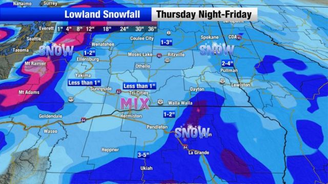
Arctic air pushing through the Gorge and across northwest Oregon and southwest Washington on Friday is likely to bring light snow, potentially 1 or 2 inches, according to meteorologist Matt Zaffino. The forecast for heavy snow and exact amounts remains uncertain and depends on the Pacific storm’s landfall location.
South of the snow, there’s a significant chance of heavy freezing rain, expected from Salem south to Eugene, although this area may shift based on the storm’s onshore position.
Meteorologist Rod Hill points out that temperatures will start near 40 degrees early Friday, dropping below freezing during the day. The amount of snow accumulation is still uncertain, posing challenges in predicting its impact on traffic.
Due to eastward-moving Arctic air, Friday night could see the development of an icy mix that includes snow pockets, freezing rain, and sleet as well as bitterly cold wind chills on Saturday.
By Saturday morning, temperatures are expected to drop into the teens, setting the stage for a Pacific storm with abundant moisture approaching the Oregon Coast. This moisture, combining with the Arctic air, is likely to result in heavy snow, primarily in the northern Willamette Valley.
The convergence of a warm, moisture-rich weather system over the Pacific Ocean and a mass of cold Arctic air descending across Canada towards the northern United States is what fuels the winter storm forecast. The precipitation totals for this winter storm are challenging to pinpoint because of uncertainty about Pacific moisture movements and east winds from the Gorge.
As icing begins to develop in parts of the valley on Saturday, significant ice and snow accumulation become possibilities. The NWS warns that travel could be very difficult throughout the weekend, and the combination of ice and possible 35 mph wind gusts may damage trees and cause power outages.
The Winter Storm Watch encompasses the entire metro area, extending from the coast through the valley to the gorge. A separate Winter Storm Watch is also in effect for the northern Oregon Cascade foothills and the Silver Falls State Park area.
In Seattle, meteorologist Steve Reedy emphasizes the challenges in forecasting snow in the lowlands. Despite early doubts, a wintry mix of snow, hail, and sleet emerged late Thursday afternoon, sticking to surfaces while roads remained wet.
The European weather model consistently places the snow-maker in Oregon, raising the prospect of substantial snowfall in Portland.
The main U.S. model, the GFS, now aligns with the European model, suggesting frosty conditions without significant snowfall in most lowland areas. Cool showers on Thursday are expected to spread through the lowlands, with heavier showers potentially producing a brief inch of snow on higher hills.
The cold arctic air mass descending on Western Washington from Canada is likely to bring Seattle’s coldest days on Friday and Saturday.
Uncertainty remains about the severity of cold, with Friday’s forecast high ranging from 17 to 26 degrees. Despite the challenging conditions, Seattle’s forecast low of 14 degrees on Sunday morning would be the coldest since 2010. The weather service advises residents to protect pipes, account for extra travel time, and ensure pets are kept warm.
As both Portland and Seattle navigate these complex weather systems, preparations are underway to respond to potential challenges. The King County Regional Homelessness Authority has activated its severe weather response, providing emergency shelters and warming centers in Seattle and throughout the region.
As the Pacific Northwest braces for these intense winter storms, residents are urged to stay informed, prepared, and vigilant in the face of unpredictable weather conditions.
The interplay of Arctic air, Pacific storms, and shifting weather models adds a layer of complexity to the already unpredictable nature of winter storms in the region. Meteorologists acknowledge the difficulty in pinpointing precipitation totals and the exact trajectory of the storms due to the intermingling of east winds from the Gorge and the uncertainty of Pacific moisture movements.
As the Winter Storm Watch covers a vast area, from the coast through the valley to the gorge, residents are advised to stay updated on weather forecasts and adhere to safety precautions. The possibility of blizzard conditions developing in the Columbia River Gorge on Friday, with heavy snow, gusty winds, and freezing spray on the river, raises concerns about potential traffic disruptions.
Beyond Portland and Seattle, the northern Oregon Cascade foothills and the Silver Falls State Park area are also under a Winter Storm Watch, anticipating heavy snowfall and possible accumulations of 1-3 feet above 1,500 feet. The geographical diversity of these alerts highlights the widespread impact expected from the upcoming winter storms.
While the focus remains on weather patterns and potential disruptions, the broader context emphasizes the need for community readiness and support. The NWS’s updated criteria for issuing Winter Storm Watch and Winter Storm Warning notices reflect a proactive approach, with Oregon likely to see more frequent alerts. The threshold for Portland has been set at 3 inches of forecasted snow, underlining the commitment to keeping residents well-informed and prepared.
Seattle’s preparations include activating the severe weather response by the King County Regional Homelessness Authority. With 24/7 emergency shelters and warming centers in place, the city aims to ensure the safety and well-being of vulnerable populations during the cold spell.
As temperatures plunge to some of the coldest on record, the weather service’s urging for people to protect pipes, account for extra travel time, and keep pets warm underscores the potential challenges posed by this winter weather episode.
In conclusion, the Pacific Northwest is bracing for a complex and impactful winter storm, with Portland and Seattle at the epicenter. The convergence of Arctic air and Pacific storms creates a dynamic weather scenario, challenging meteorologists and residents alike.
The interplay of various factors, from eastward-flowing winds to uncertain moisture movements, adds layers of unpredictability to the forecast.
As communities prepare for potentially disruptive weather conditions, the importance of staying informed, adhering to safety guidelines, and supporting vulnerable populations comes to the forefront. The collaborative efforts of meteorological services, local authorities, and community organizations aim to mitigate the potential impacts of these intense winter storms.
As residents navigate this winter whirlwind, a collective commitment to readiness, resilience, and community support becomes paramount in facing the challenges posed by Mother Nature’s wintry embrace.